It’s raining sand in Rayalaseema
Changes in crop patterns, waning forest cover, an explosion of borewells and the death of a river have produced dramatic effects on land, air, water and forests in Rayalaseema

Changes in crop patterns, waning forest cover, an explosion of borewells and the death of a river have produced dramatic effects on land, air, water and forests in Rayalaseema
It’s a classic Indian cinema fight-in-the-desert scene. Against the background of dunes and depressions with a tiny sprinkling of scrub vegetation, the hero rises from the burning sands of a barren wasteland to beat the bad guys to a pulp. Adding plenty of heat and dust to that already bestowed by nature, he brings the film to a happy conclusion (except for the villains). Countless Indian movies have staged those scenes in some desolate wilderness of Rajasthan. Or even in the ravines of the Chambal valley in Madhya Pradesh.
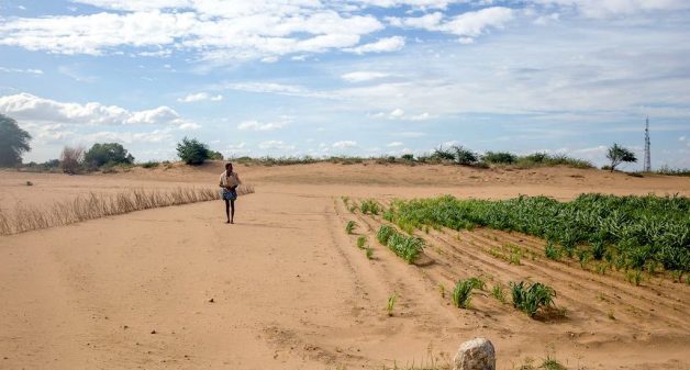
Only, this arid wilderness scene (see video clip) used no locations from Rajasthan or the Chambal. It was shot deep in the southern peninsula, in Andhra Pradesh’s Rayalaseema region. This specific patch of some 1,000 acres in Anantapur district – once covered by millet cultivation – has over many decades become more and more a desert. That has been driven by often paradoxical factors – and created the kind of space that filmmakers send out location scouts to look for.
In Dargah Honnur village, where the major landowners of this patch reside, it was difficult to get anyone to believe we were not movie location scouts. “Which film is this for? When is it coming?” was either an explicit question or one on their minds. With some, you could see a quick ebbing of interest when they learned we were journalists.
The makers of the Telugu film that made the place famous – Jayam Manade Raa (Victory is Ours) – shot those fight scenes here between 1998 and 2000. Like any diligent commercial filmmakers would, they tinkered with their ‘set’ to enhance the desert effect. “We had to uproot our crop (for which they compensated us),” says Pujari Linganna, 45, whose family owns the 34 acres where the fight was shot. “We also removed some vegetation and small trees so it would look more real.” Deft camerawork and the intelligent use of filters did the rest.
Tormented nature
If the makers of Jayam Manade Raa were shooting a 20-years-after sequel today, they would have to do much less. Time and tormented nature, and relentless human intervention, have effected all the desert enhancements they could ask for.
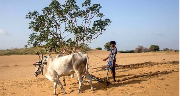
But it’s a curious desert patch. There is still cultivation – because there is still groundwater very close to surface. “We hit water in this patch at just 15 feet below,” says P. Honnureddy, Linganna’s son. In much of Anantapur, borewells won’t find water before 500-600 feet. In parts of the district, they have breached the 1,000-foot mark. Yet here is water gushing out of a four-inch borewell as we speak. That much water, so close to the surface, in this hot and sandy patch?
“That whole area lies in an extended riverbed,” explains Palthuru Mukanna, a farmer from a nearby village. What river? We can see nothing. “They built a dam [around five] decades ago, some 25-30 kilometres from Honnur, on the Vedavathi river that ran through here. Our stretch of Vedavathi (a tributary of the Tungabhadra – also called the Aghari) simply dried up.”
“That is indeed what happened,” says Malla Reddy of the Ecology Centre (of Anantapur’s Rural Development Trust) – few know this region as well as he does. “And the river may be dead but, over centuries, it helped create an underground reservoir of water that is now being relentlessly mined and extracted. At a rate which signals a coming disaster.”
That disaster won’t be long in coming. “There was hardly a single bore 20 years ago,” says V. L. Himachal, 46, a farmer with 12.5 acres in the desertified area. “It was all rainfed agriculture. Now there are between 300-400 borewells in about 1,000 acres. And we strike water by 30-35 feet, sometimes higher.” That’s one borewell to every three acres, or less.
Burdened with borewells
That’s high density, even for Anantapur which, as Malla Reddy points out, “has close to 270,000 borewells, though the carrying capacity of the district is 70,000. And almost half this huge number are dry this year.”
So what are the borewells in these badlands for? What’s being cultivated? What sticks out in the patch we’re exploring is not even the district’s all-pervasive groundnut crop, but bajra. That millet is cultivated here for seed multiplication. Not for consumption or the market, but for seed companies who have contracted the farmers for this job. You can see male and female plants laid out neatly in adjacent rows. The companies are creating a hybrid from two different strains of bajra. This operation will take a great deal of water. What’s left of the plant after seed extraction will at best serve as fodder.

“We get Rs 3,800 per quintal for this seed replication work,” says Pujari Linganna. That seems low, given the labour and care involved – and the fact that the companies will sell those seeds to the same class of farmers at very high prices. Another cultivator on this patch, Y. S. Shantamma, says her family gets Rs 3,700 a quintal.
Shantamma and her daughter Vandakshi say the problem of cultivating here is not water. “We even get water in the village though we have no piped connection at home.” Their headache is the sand which – besides the huge volume that already exists – can accumulate very rapidly. And trudging across even short distances on sand several feet deep can be tiring.
“It can simply destroy the work you’ve put in,” say mother and daughter. P. Honnureddy agrees, showing us the stretch beneath a sand dune where he had painstakingly laid out rows of plants – not four days ago. Now they are just furrows covered in sand. This place, part of an increasingly arid zone which sees strong winds hit the village, has sandstorms.
“Three months in the year – it’s raining sand in this village,” says M. Basha, another desert cultivator. “It comes into our homes; it gets into our food.” The winds bring sand flying into even those homes not so close to the dunes. Netting or extra doors don’t always work. “Isaka varsham [sand rain] is part of our lives now, we just live with it.”
The sand scourge
The sands are not strangers to D. Honnur village. “But yes, their intensity has risen,” says Himachal. A lot of shrubbery and little trees that formed serious wind barriers have gone. Himachal speaks knowledgeably of the impact of globalization and market economics. “Now we calculate everything in cash. The shrubs, trees and vegetation went because people wanted to use every inch of land for commercial cultivation.” And “if sands fall when seeds are in germination or sprouting,” says farmer M. Tippaiah, 55, “the damage is total.” Yields are lower despite their access to water. “We get three quintals of groundnut an acre, at best four,” says farmer K. C. Honnur Swamy, 32. The district’s average yield is around five.
They see no value in natural wind barriers? “They will only go for trees that have commercial value,” says Himachal. Which, unsuited to these conditions, may not grow here at all. “And anyway, the authorities keep saying they will help with trees, but that hasn’t happened.”
“A few years ago,” says Palthuru Mukanna, “several government officials drove out into the dunes area for an inspection.” The desert safari ended badly and their SUV, mired in the sands, had to be towed out by the villagers with a tractor. “We haven’t seen any more of them since,” Mukanna adds. There are also periods, says farmer Mokha Rakesh, “when the bus cannot go that side of the village at all.”
The loss of shrub and forest is a problem across the entire Rayalaseema region. In Anantapur district alone, 11 per cent of area is classified as ‘forest’. Actual forest cover has dwindled to less than 2 per cent. That has had the inevitable impact on soil, air, water, and temperatures. The only large forest you see in Anantapur is the jungle of windmills – thousands of them – dotting the landscape everywhere, even bordering the mini-desert. These have come up on land purchased or leased long-term, by windmill companies.
Back in D. Honnur, a group of desert-patch cultivators assures us that things were always this way. They then go on to present compelling evidence to the contrary. The sands have always been there, yes. But their force, producing sandstorms, has grown. There was more shrub and cover earlier. Very little now. They’ve always had water, yes, but we learn later of the death of their river. That there were very few borewells two decades ago, hundreds now. Every one of them recalls a spike in the number of extreme weather episodes these past two decades.
Changing rainfall patterns
Rainfall patterns have changed. “In terms of when we need the rains, I’d say they are 60 per cent less,” says Himachal. “There’s less rains around Ugadi [Telugu New Year’s Day, usually in April] these past few years.” Anantapur is touched – gingerly – by both south-west and north-east monsoons but derives the full-benefit of neither.
Even in years when the district receives its annual average rainfall of 535 mm – the timing, spread and dispersal have been terribly erratic. In some years, the rains have moved from crop to non-crop seasons. Sometimes, there’s been a huge downpour in the first 24-48 hours and great dry spells afterwards. Last year, some mandals saw dry spells of almost 75 days during the crop season (June to October). With 75 per cent of Anantapur’s population in rural areas and 80 per cent of all workers engaged in agriculture (either as farmers or laborers), this proves devastating.

“There have been just two really ‘normal’ years in Anantapur in each of the last two decades,” says Malla Reddy of the Ecology Centre. “In every one of the remaining 16 years, two-thirds to three-fourths of the district has been declared as drought-affected. In the 20 years prior to that period, it was three droughts every decade. The changes that began in the late 1980s have hastened every year.”
A district once home to a multitude of millets switched increasingly to commercial crops like groundnut. And saw, correspondingly, a massive sinking of borewells. (A report of the National Rainfed Area Authority says there are now “pockets where groundwater exploitation has exceeded 100 per cent.”)
“Forty years ago, we had a clear pattern – three droughts in 10 years – and farmers knew what to plant. There were between 9 and 12 diverse crops and a stable cultivation cycle,” says C.K. ‘Bablu’ Ganguly. He leads the Timbaktu Collective, an NGO which for three decades has focused on the economic betterment of the rural poor in this region. His own four-decade engagement here has given him tremendous insight into the region’s farming.
“Groundnut [now covering 69 per cent of cultivated area in Anantapur] did to us what it did to the Sahel in Africa. The monocropping we descended into didn’t just alter the water situation. Groundnut can’t take shade, people remove trees. Anantapur’s soil was destroyed. Millets were decimated. The moisture is gone, making a return to rainfed agriculture difficult.” Crop changes also undermined the role of women in farming. Traditionally, they were custodians of the seeds of the diverse rainfed crops grown here. Once farmers began to buy seed on the market for the cash crop hybrids that took over Anantapur (as with groundnut), the role of women was reduced largely to that of laborers. Also lost, over two generations, were the skills of many farmers in the complex art of growing multiple, varied crops on the same fields.
Fodder crops now account for less than 3 per cent of cultivated area. “Anantapur once had one of the highest numbers of small ruminants in the country,” Ganguly says. “Small ruminants are the best asset – mobile property – of ancient communities of traditional herders like the Kurubas. The traditional cycle where the herders’ flocks provided post-harvest manure to the farmers’ fields in the form of dung and urine – that’s disrupted by changing crop patterns and chemical agriculture. Planning for this region has proved hostile to the marginalised.”
Shrinking farm biodiversity
Himachal in Honnur recognizes the shrinking agricultural biodiversity around him and its consequences. “Once, in this very village, we had bajra, cowpea, pigeon pea, ragi, foxtail millet, green gram, field beans…” he rattles off a list. “Much easier to cultivate, but rainfed agriculture doesn’t bring us cash.” Groundnut did, for a while.
The crop cycle of groundnuts is around 110 days. Of those, it only covers the soil, protecting it from erosion, for 60-70 days. In the era when nine different millets and pulses were grown, those offered the topsoil a protective shade cover from June to February each year, with one or the other crop always on the ground.
Back in Honnur, Himachal is reflective. He knows that borewells and cash crops brought great benefits to the farmers. He also sees the declining trend in that – and the growing out-migrations as livelihoods shrink. “There are always over 200 families seeking work outside,” says Himachal. That’s a sixth of the 1,227 households the 2011 Census records for this village in Anantapur’s Bommanahal mandal. “Around 70-80 per cent of all households are in debt,” he adds. Farm distress has been high across Anantapur for two decades – and it is the district in Andhra Pradesh worst affected by farmer suicides.
“The boom time of borewells is gone,” says Malla Reddy. “So is that of cash crop and monocultures.” All three still proliferate, though, driven by that fundamental shift from production for consumption to “creating products for unknown markets.”
If climate change is simply about nature pressing its reset button, then what was it we saw in Honnur and Anantapur? Also, as the scientists tell us, climate change occurs across very vast natural regions and zones – Honnur and Anantapur are administrative units, mere specks, too small to qualify. Can it be that large canvas changes across much greater regions might sometimes aggravate existing freakish features of sub-regions within them?
Almost all the elements of change here resulted from human intervention. The ‘borewell epidemic’, the massive switch to commercial cropping and monocultures; the loss of biodiversity that could be Anantapur’s best defence against climate change; the ongoing exhaustion of the aquifer; the devastation of the little forest cover this semi-arid region had; the harming of the grassland ecology and a serious degradation of the soil; the industry-driven intensification of chemical agriculture; the crumbling of symbiotic relationships between farm and forest, shepherds and farmers – and the loss of livelihoods; the death of rivers. All these have clearly impacted temperatures, weather and climate – which have in turn further aggravated these processes.
If human agency, driven by a model of economics and development gone berserk, is a major driving factor in the changes upon us, there’s plenty to be learned from this region and many like it.
“Maybe we ought to shut down the borewells and return to rainfed farming,” says Himachal. “But it’s too difficult.”
P. Sainath is a veteran journalist and a pioneer in rural reporting. He is Founder Editor of the People’s Archive of Rural India. Views are personal.
This was first published in the People’s Archive of Rural India.